Walk 5 - St Paul’s Bay to Mellieha Town via Selmun Palace
Saturday, 27th March 2004.

Approximate Distance 5 miles (or 6.25 mile if diversion is taken)

We had been looking forward to this part of our ramble across Malta as it would give us an opportunity to revisit the area around Mistra Bay and Selmun Palace, which we consider to be one of the prettiest parts of the island.

Leaving our hotel base in St Paul’s Bay our route was very easy. We walked west along the small coastal roads, passing the Wignacourt Tower, admiring the views seawards and thinking how fortunate the residents of the houses on our left were to live in a location with such stunning vistas. We were n’t in a hurry so we made good use of the numerous benches situated along this route to admire these views, particularly those towards Mistra Bay and St Paul’s Island, and of course Selmun Palace, located high above Mistra Bay.

Looking towards St Paul's Island from near the Wignacourt Tower.

We followed the route adjacent to the coast as long as possible but we were forced inland on to the main bus route between Mellieha and St Paul’s Bay when the minor roads along the coast ended. Looking at the photograph the road reminds be of a set for the film the "Guns of Navarone" with its bleakness and emptyness.

At one point, to get closer to the sea, we went down a steep road, about 1 in 5, with grooves across it to help vehicle traction. However, we only had a fleeting glimpse of the water before we had to ascend back to the bus route. This walking along the bus route road, with no sea views, only lasts for about ½ mile before the road runs alongside the sea, and the narrow path we had travelled become a wide and level promenade.

Click to enlarge Click to enlarge Click to enlarge Click to enlarge
The bus route between St. Paul's Bay and Mellieha.
One of the steep roads down to the sea.
The promenade on the approach to Xemxija.
Looking towards Xemxija (left) and Mistra (right)

At the end of this promenade is a traffic island and close to it are public toilets, which in their present condition would never win the Maltese Good Loo Guide and should only to be used in dire emergencies.

Our route now continued uphill, still with the sea on our right, towards Xemxija. In Xemxija, just after the sea view vanishes (more buildings), and the footpath is also no more, there is a road on the right called Shipwreck Terrace. This we took and, as it went downhill, we recovered the sea views before our path went sharp left and uphill to return to the main road and bus route.

At the main road, the route is right (uphill), over a traffic island on the brow of the hill and downhill for about a ¼ of a mile to a turning on the left, which bends right and goes under the main road and is signposted to Mistra Bay. The road between the traffic island and the Mistra Bay turn is, besides being very busy, quite narrow and without a footpath. However, there is a low wall, about 18” wide with a level top, which we walked along to avoid the traffic.

Once on the road to Mistra Bay the walking is so much more pleasant. On either side of the road are small cultivated fields with their boundaries marked by dry stone walls. On the right hand side are also tall bamboo groves and, in spring, flowers are in evidence making the whole area very colourful.

Click to enlarge Click to enlarge Click to enlarge Click to enlarge
Turn left off the road to Mellieha.......
....and enter the much quieter road the goes to Mistra Bay.......
...with bright colourful borders.......
......and stone walls

Although we could have followed the road all the way to Mistra Bay, about 5 minutes before we would have reached the bay, we took a path on our left and headed uphill towards Selmun Palace, which can be seen at the top of this ascent.

The climb uphill to Selmun Place is quite steep – the steepest pull of any of the ascents on this route. But the views looking back are superb and it is essential to stop and spend a few minutes looking at the sea, Mistra Bay, St Paul’s Bay and a great deal of the route already walked. To the left, as you look seawards, the old army barracks can be seen at Fort Campbell and everywhere are flowers to add colour to the cultivated vegetation.

Click to enlarge Click to enlarge Click to enlarge Click to enlarge Click to enlarge
Photographs taken on the path between the Mistra Bay Road and Selmun Palace.
Left to right - Mistra Bay - Fort Campbell - the path - flowers - looking down the path.

Towards the top of the path the route is covered by concrete, which I always find a lot easier to walk on than the loose terrain below. When the top is reached, turn right and in a few yards the corner of a metal track is reached. The quickest way here is to go left and, passing Selmun Palace on the right, go right and immediately left down a track. Click here if you want to go ignore the diversion which follows.

However, we decided on a slight diversion and went right at the corner and headed towards Fort Campbell. This would give us an opportunity to see more of this beautiful area. We passed a house on our left and soon had fields on both sides of our route.

After about half a mile we reached a path on our left (between a wall on its left and scrubland on its right). This we took and soon it went downhill to meet a metalled lane on a right hand bend. Here we went left, gradually going uphill, and then left round a hairpin bend. We just followed the lane, enjoying the views, especially northwards towards Marfa Ridge, and the warm sunshine. We reached and passed the Selmun Palace Hotel. However, before reaching the Selmun Palace itself we turned right down a track.

Click to enlarge Click to enlarge Click to enlarge
Views enjoyed on the diversion.

This track is initially very wide but as it gets close to a small house, which is almost hidden by the vegetation, it narrows. However, once the house is past the path gets wider as it goes downhill and we were able to see houses ahead of us on the outskirts of Mellieha Town. These are in the required direction, so at the bottom of the hill the paths going left and right are ignored. It's then uphill, the path swings left and then right before reaching a road with houses immediately opposite.

Looking towards Mellieha

At the road the way is left passing some very impressive properties, initially on the right, but soon on both sides of the road. Within a ¼ mile we could see the Belle View Hall ahead, home of renowned local bakery.

Click to enlarge Click to enlarge
Looking back to Selmun Palace
Approaching Belle View Hall

Turning right at the main road, we initially have more uphill walking to do as we pass houses and shops and enjoyed occasional views of the sea to our right. After the road does a sharp left it descends towards the busy centre of Mellieha Town and Mellieha Bay beyond. However, we decide to end this part of our walk by George’s Bakery and having purchased some food we cross the road to catch a no. 45 bus to St Paul’s Bay where we enjoyed our purchases with a bottle of red wine on our sunny balcony. Wonderful.


Previous
Page

Top of Page
Next Walk
Join GreasyPalm.co.uk - the site that PAYS YOU to shop!
Walk Malta - from Marsaxlokk/Delimara Point to Cirkewwa
Walk 1 - Marsaxlokk/Delimara Point to Marsascala.
Walk 2 - Marsascala to Sliema via Vittoriosa, the Grand Harbour and Valletta.
Walk 3 - Sliema to Bahar ic-Caghaq
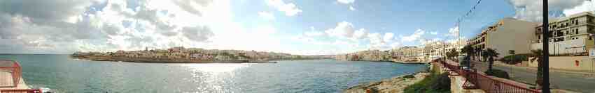
 (Ronnie's Bar).
Walk 4 -Bahar ic-Caghaq (Ronnie's Bar) to St. Paul's Bay.
Walk 5 - St. Paul's Bay to Mellieha via Selmun Palace.
Walk 6 - Mellieha to Cirkewwa.
Walk Malta - End Thoughts.
Go to Brilwalks.com main website and some favourite walks.
Walk Malta - Links & Things